At A Glance
The Castle at a Glance
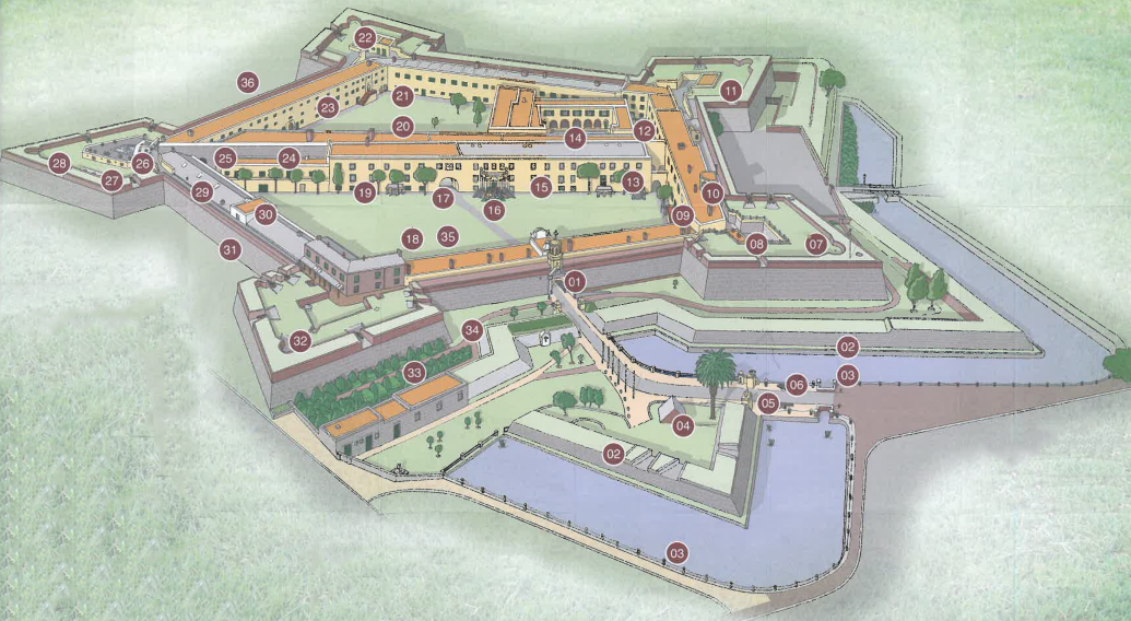
The headline numbers, dates and dimensions that define South Africa’s oldest surviving colonial building - followed by a labelled map showing the thirty-six features inside its star-shaped walls.
Built By
Dutch East India Company
(VOC) — Vereenigde Oostindische Compagnie, the “United East Indian Company”
Construction
1666 – 1679
Thirteen years to build
Design
Pentagonal Bastion Fort
Five-pointed star, trace italienne style
Walls
10m
Up to ten metres high · three metres thick at the base
Foundations
3.5m
Three and a half metres deep · five metres wide
Status
National Heritage Site
Declared in 1936
Location
Darling & Buitenkant Streets
Cape Town, South Africa
Flags Flown
6
Six powers, over more than 350 years
Sieges Attempted
0
Never taken by direct assault
Inside the Walls
- 01 Main Entrance & Bell Tower
- 02 Ravelin
- 03 Moat
- 04 Arsenal
- 05 Outer Entrance with Lion Posts
- 06 English 18-Pounder
- 07 Leerdam Bastion
- 08 Restitution Garden
- 09 Vertical Sundial
- 10 Captain’s Tower
- 11 Oranje Bastion
- 12 Krotoa Memorial
- 13 Lady Anne Barnard Banquet Hall
- 14 Het Bakhuys & Dolphin Pool
- 15 Governor’s Quarters & Council Chambers
- 16 Kat Balcony & “Kings of the Castle”
- 17 Inner Archway
- 18 Front Courtyard
- 19 Slaves Quarters
- 20 Back Courtyard (Wapenplaats - Weapon Yard)
- 21 Torture Chamber & Dark Hole
- 22 Nassau Bastion
- 23 Centre for Memory, Healing and Learning
- 24 Secunde’s Hall (Fired Ceramic Exhibition)
- 25 Ammunition Room in Dungeon
- 26 Jail
- 27 Hotchkiss Signalling Guns’ Mounts
- 28 Katzenellenbogen Bastion
- 29 King Cetshwayo Detention Area
- 30 Military Museum
- 31 Waterpoort (Original Main Entrance)
- 32 Buuren Bastion
- 33 Garden
- 34 Cape Khoi Kraal Exhibition
- 35 Restaurant
- 36 Sally Port Entrance (Sea Facing)